Diagram / Infographic
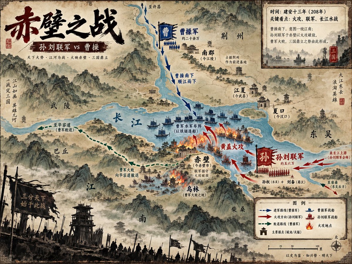
Battle of Red Cliffs Map
Goal: Create a richly detailed ancient Chinese ink-and-wash strategic visualization map of 赤壁之战, showing the Battle of Red Cliffs as a historical military map with painterly mountains, rivers, fleets, arrows, burning ships, labeled cities, and parchment texture.
Fields you can change: battle name, main title, subtitle.
Full prompt
Goal: Create a richly detailed ancient Chinese ink-and-wash strategic visualization map of {argument name="battle name" default="赤壁之战"}, showing the Battle of Red Cliffs as a historical military map with painterly mountains, rivers, fleets, arrows, burning ships, labeled cities, and parchment texture.
Canvas: Horizontal 4:3 map poster, aged tan rice-paper background with darkened worn edges, decorative corner border ornaments, ink stains, faded seals, and a hand-painted Song/Ming dynasty atlas aesthetic. Use a slightly elevated bird’s-eye view with the Yangtze River as the dominant blue waterway cutting across the center.
Main title area: Place a huge black-and-dark-red Chinese brush-calligraphy title in the upper left reading {argument name="main title" default="赤壁之战"}. Beneath it, add a dark red banner subtitle reading {argument name="subtitle" default="孙刘联军 vs 曹操"}. Add a small supporting line below in fine Chinese type: “天下大势 · 江河为战 · 火映赤壁 · 三国鼎立”.
Map geography and labels: Show exactly 11 major geographic/place labels in Chinese across the map: 1) 武陵 on the left-central mountains, 2) 巴丘 lower left of the river, 3) 长江 written large on the central river, 4) 南郡(今江陵)upper center-right, 5) 荆州 upper right, 6) 江夏(今武昌)right of river, 7) 夏口(今汉口)far right river bend, 8) 东吴 far right, 9) 赤壁(今赤壁市)near the central fire battle, 10) 乌林(曹军大败之地)below Red Cliffs, 11) 柴桑 lower right. Include misty mountain ranges, watchtowers, walled towns, small villages, docks, and forested islands.
Battle layout: Depict exactly 2 opposing forces. The northern/upper force is Cao Cao’s army, colored blue, with a blue vertical banner “曹” and a label “曹操军 约二十余万”; show blue infantry ranks and fleets moving south along the river. The southern/lower-right force is the Sun–Liu allied army, colored red, with a large red banner “孙” and label “孙刘联军 约五六万”; show red infantry ranks and warships launching the attack. Use dramatic red fire arrows and burning ships at the central river near Red Cliffs. Add the key action label “黄盖火攻” in red near the flames, and label the blue fleet formation “曹军水军布阵(以铁链连船)”.
Movement arrows: Include exactly 4 arrow systems: 1) blue dashed arrows descending from the north labeled “曹操南下 顺江而下”, 2) red attack arrows curving from the southeast toward the burning fleet labeled “黄盖火攻”, 3) green dashed retreat arrows running west/southwest labeled “曹军大败 向华容道撤退” and “至华容道(曹军败退)”, 4) red reinforcement arrows from the far right labeled “来自江上游(孙刘联军会师)” and “至柴桑(朱吴后方)”.
Inset information panel: In the upper right, add a parchment-framed rectangular inset with a small monochrome river battle illustration and exactly 4 Chinese text lines: 1) “时间:建安十三年(208年)”, 2) “关键看点:火攻、联军、长江水战”, 3) “曹操南下,意图一统江南;”, 4) “孙刘联手于赤壁以火攻破敌,曹军大败,三国鼎立之势由此形成。” Add a small red seal marked “三国”.
Legend and scale: In the lower right, create a framed legend titled “图例” with exactly 6 legend items: 1) blue dashed arrow “进军路线(曹操军)”, 2) red arrow “火攻方向(孙刘联军)”, 3) green dashed arrow “败退路线(曹操军)”, 4) blue boat icon “曹操军战船”, 5) red boat icon “孙刘联军战船”, 6) flame icon “火攻地点”. Include a simple scale bar marked 0, 25, 50, 100 里 and a compass rose labeled 北.
Foreground atmosphere: Along the bottom edge, add a dark silhouetted battlefield foreground with wooden watchtowers, banners, spears, soldiers, smoky mist, and a broken black war flag bearing the phrase “一分天下 始于此战”.
Visual style: Classical Chinese shanshui map painting mixed with modern infographic clarity; sepia parchment, muted teal-blue river, black ink mountains, red and blue army color coding, delicate Chinese typography, dramatic but readable. Use dense historical detail but keep all labels legible and map symbols consistent. No photorealism, no modern objects, no watermark.